OSINT in Japan (日本) — Street OSINT Part 2
Part 1 was all about visual identifiers on a road in Japan, in this article I would like to focus on traffic street signs and provide a small guide on reading them. I will look at national expressway signs, national highways signs and prefectural road signs.
STREET SIGNS
Street signs can be solely in Japanese or in both Japanese and English. Depending on where in Japan we are, signs can be seen overhead, by the traffic lights or in the middle of the road. Because of the Tokyo Olympic Games, many streets signs have English now alongside Japanese but many places around the country still don’t.
Expressways
Expressways in Japan consist of national expressways, which are the majority of the expressways and urban expressways.
Urban expressways are the Shuto Expressways and Tokyo Expressways amongst 5 others.
- Hanshin Expressway
- Nagoya Expressway
- Fukuoka Expressway
- Hiroshima Expressway
- Kitakyūshū Expressway
Signs on an expressway are usually green and white and consist of the letter E followed by a maximum of 2 digit numbers and then sometimes another letter. This would help us understand what is around us when looking on a map.
‘E’ at the start= expressway, non circular route
‘A’ at the end = group route
‘C’ at the start = circular route

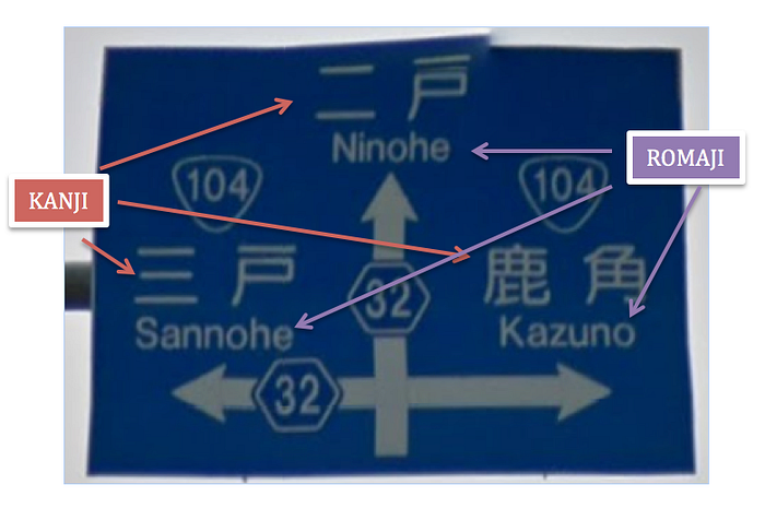
The name of the expressway is not always written on the signs, in this case we have all 3 options given to us. The route number, E26, the name of the route, Kinki expressway and the Kanji translating to Kinki expressway.
近 畿 道 = Kinki road
Expressway routes are numbered according to the national highway routes that they are parallel with. With exceptions and variations but worth keeping this in mind.
For example, I came across E26 — Kinki Expressway on a Geoguessr map. Going by that theory I should expect to see National Route 26 somewhere parallel. The blue inverted triangle ‘26’ (left) is parallel to the green rectangle ‘E26’ (right). This helps when you spot one on the map and not the other.


If you just find the route number or just the name of the expressway, here is a list of expressway numbers and their corresponding route names. And here they are on an interactive map of all expressways. I have been able to quickly skim through the map looking for the route I needed and to see exactly where it started and where it ended giving me a much small area to look into. Zoom in and it will go into more detail including showing the national routes too.
Tokyo’s metropolitan expressway maps and links

Shuto expressway is a network of expressways in Tokyo. They are shown as half green cylinders icons on the map.
And this is what the routes on the map are called:
https://en.wikipedia.org/wiki/Shuto_Expressway
For example:
Route 1(North) is Ueno Route from Edobashi Junction to Iriya.


Exit and entry signs on a familiar Google maps and on Street View.
https://www.shutoko.jp/use/network/
入口 = Entrance
出口 = Exit
The following links are maps that can be used for more detailed analysis. They have helped me move around Tokyo smoother and recognise entrances and exits on the map. Another reason why I value these maps is because they also show me the names of the neighbourhoods in Kanji (Japanese alphabet) which all street signs are in. Some street signs are only in Kanji and these can be used for visual reference. Unless it is a complicated character some can be used to visually match them on here (I have used this in extreme cases on Geoguessr, understandably a very tough task).
1. — Exit and entry points by neighbourhood
2. — Exit and entry points by direction, left and right
1 and 2 are very similar but the second link gives a more specific exit point.

左 = Left
右 = Right

入口 = Entrance
出口 = Exit
The following map translates all Shuto expressways from Kanji to English so anywhere where English isn’t available or a translate isn’t possible try this as well. This is only for the Shuto Expressway.
https://www.shutoko.co.jp/company/database/route/
Kanji are adopted logographic Chinese characters that are used in the Japanese writing system. Kanji is seen in most if not all street signs along with romaji (a way to write Japanese by using Latin script).
National highways and prefectural roads
On a blue overhead street sign national highways can be distinguished by its inverted triangle shield shape sign. The prefectural roads can be distinguished by their hexagon shaped signs.
List of all national highways of Japan, where they start and where they end.
https://en.wikipedia.org/wiki/List_of_national_highways_of_Japan

In big cities, route signs are also present on the roads and a lot of the plates are coloured according to what type of road it is.


Kanji Part 1
Here are few Kanji that might come up on an overhead street sign that can give you an idea what is around you. These are only to be translated literally if they are alone. If they are accompanied by another character or part of a road name it will then change its meaning and translation.
川 = River
山 = Mountains
県道 = Prefectural Road
国道 = National Route
橋 = Bridge
This was just a short visual guide on some of the most common street identifiers in Japan, there are of course many more and much more detail for each of them but I will cover a few more types in the next few blogs. If you think something is incorrect or you disagree please drop me a message.
Are you playing a world challenge? Then try geotips.net for tips and tricks on every country on Geoguessr.